Thursday, May 16, 2013

Guide to the Blog

By: Emily Trejo Sypolt for Wildlife 420 (Waterfowl Management)

Photo: Swans swimming in a canal
This is the first page that shows up when the blog is accessed. It is meant to be a guide through the blog.

Element 1 talks about the favorite 24 waterfowl species with pictures, range maps and natural history information.
Element 2 talks about our assigned readings including Wild Goose Dilemmas and Waterfowl Ecology. Along with these two books, I included background readings. Background readings are signified by this symbol to the right. With every background reading, the symbol will have a link to that reading, or the link will be right next to the symbol.
Element 3 talks about conservation and management
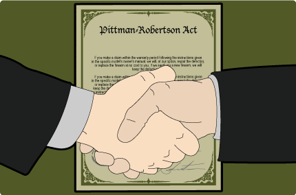
Element 4 talks about historical and current actions of the United States of America's plans to manage waterfowl (including NAWMP, Migratory Bird Treaty Act)
Element 5 talks about conservation on a global scale and what other countries are doing as far as waterfowl are concerned.
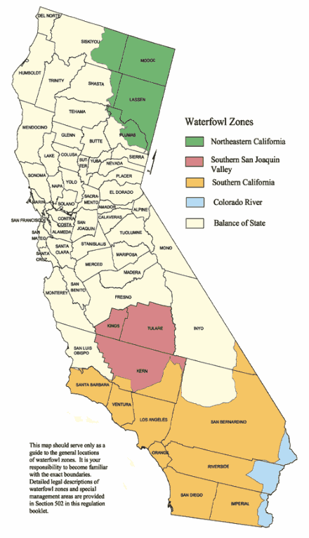
Element 6 discusses local waterfowl we encountered with background readings, as well as observations and field trips we went on.

The main books I gained information from (as well as a wide array of background reading/videos/informational websites) was:


None of the photographs or graphics belong to me, I received them thanks to Google (I have no idea who their original owners are).

Also, all "case studies" were taken from presentations that students did in class during our symposium.

Pittman-Robertson Act

Established in 1937 by Franklin D. Roosevelt, the Pittman-Robertson Act was a tax on gear used for hunting (including cameo, ammunition, guns, decoys). With this act, wood duck species have been able to rebound due to the large amount of money gained from this act and projects that are able to be put forth due to the incoming money from the taxes. In 50 years, approximately 2 billion dollars has been raised for projects of wildlife restoration from this act and has been matched by approximately 500 million dollars from states (licensing hunting fees). There is no doubt that hunting has contributed a lot of funds to wildlife restoration, and the depletion of funds could potentially be detrimental for protecting waterfowl and wetland habitats (Think: what would we do without the 2 billion dollars raised from this act alone?).
Accomplishments:

  • 40 million acres of land has been influenced to be better habitat
  • 4 million acres have been purchased by this act for wildlife management
  • Plus many projects that have been carried out and provided scientific research for conservation

Guest Lecture: John Eadie

John Eadie of UC Davis came in to give us a talk about a pressing issue in the Central Valley. An area that we learned is critical for many waterfowl on the Pacific Flyway, approximately 4-6 million waterfowl winter there. During the winter time, the main need for waterfowl is food. So managers need to assess how much habitat is necessary in order to take care of the waterfowl and provide enough food. It is a simple calculation (maybe too simple)


Area needed = # of birds + energy/bird
                       ___________________
                         energy available/acre


This is a case of supply and demand; however, in the Central Valley the food has been running out to early and there is not enough supply to meet the demand. Assessments were done on various wetlands to see how good habitat was. There was a wide range of results, but John said all of the managers of the habitat believed their land was managed effectively to take care of the waterfowl. This was not the case as some habitat was really poor. This means we need to enhance habitat so that by chance we will not need to have so much habitat in the end, and raising awareness to managers about what good habitat is will in the end, create more supply for the waterfowl during their wintering times.
A recent study showed that the Central Valley Joint Venture establishment has been correlated with lipid reserves in some waterfowl, potentially due to the increase in land saved and the creation of optimal habitat.
Another study is being conducted currently to determine what the best way is to create optimal habitat for the waterfowl. The independent variables are the water given to the areas. This included the length of time a place was getting irrigated and how often. From this, a feasible way was found to irrigate the wetlands and just how often. Unfortunately, this method corresponded with an increase in mosquito numbers, which could be expensive to control (and it is regulated by law that it is controlled). This begs the question: how do we please everyone? Adaptive management strategies must be created for nearly everything, including how to best manage habitat for the waterfowl in the Central Valley. New methods must be implemented to find a balance between optimal waterfowl habitat, reduction in mosquitoes, public approval as well as something that is feasible. Being a manager seems a lot more difficult than I previously anticipated and many factors need to be taken into consideration. We will see what types of methods this study will present to manage for the waterfowl.

Waterfowl Hotspots

Front CoverIn Chapter 9 of this book, there is a section called Major Waterfowl Habitats in North America. He noted the most important hotspots and provided a map:

  1. Prairie Pothole Region
  2. Central Valley of California
  3. Yukon-Kuskokwim Delta
  4. Middle-Upper Atlantic Coast
  5. Lower Mississippi River Delta
  6. Izembek Lagoon
  7. Upper Missssippi River and the Northern Lakes
  8. Northern Great Plains
  9. Yukon Flats
  10. The Great Basin
  11. Teshelpuk Lake
  12. Middle-Upper Pacific Coast
  13. Klamath Basin
  14. Upper Alaska Peninsula
  15. Copper River Delta
  16. West-Central Gulf Coast
  17. Upper Cook Inlet
  18. San Francisco Bay
  19. Northeastern United States-Southerneastern Canada
  20. Sandhills and Rainwater Basin
  21. Playa Lakes
He stated that it was very difficult to include all of the important waterfowl spots since waterfowl migrate and therefore have various areas: wintering grounds, staging areas, molting areas as well as breeding areas, makes it difficult to say the critically important areas. However, he noted that there was some other important habitat types that waterfowl are associated with: 
  • Beaver ponds - they create wetlands that are desired by waterfowl. Typically waterfowl associated with forests really benefit from these areas because they can still be in the forest with a wetland near by.
  • Sewage Lagoon - Areas like the Arcata Marsh provide invertebrates  these man-made structures allow for an advantage since they are in urban areas and therefore can be managed easier.
  • Stock ponds, dugouts and farm ponds - These are usually located in grasslands and are created for livestock grazing. This allows places for waterfowl to use these ponds for food, roosting and as resting areas. 
  • Reservoirs - Large bodies of water are needed because of the huge depletion of wetlands. This provides habitat through large aquatic vegetation or if they do not have a lot of vegetation, they are usually centered near agricultural lands where waterfowl can access food. 

Flyways of North America

Administrative Flyways The map with green is considered the administrative boundaries of the pacific flyways.  These flyways enable biologists to monitor populations based on these migratory paths. There are four flyways in North America that run all the way into South America. The map below the green map is the "biological flyways" it is where the waterfowl actually migrate, as can be observed, these migration paths cross. These areas are broken up into councils between the four flyways to ensure that regional management is in effect.
Atlantic Flyway This includes parts of Canada, Puerto Rico and the U.S. Virgin Islands, illustrated by the black dots on the map.
Mississippi Flyway This includes parts of Canada and is shown by the blue on the biological map. This council was created in 1952 from a variety of agencies. (tribes, universities, states, conservation organizations)
Biological FlywaysCentral Flyway This includes parts of Canada and Mexico, shown by the green dots.
Pacific Flyway This includes parts of Canada and Mexico, illustrated by the red dots.
All of these flyway councils recommend management suggestions for the United States Fish and Wildlife to better regulate the species.
Flyways.us is a program established for waterfowl hunting management across the North American continent. This means they collaborate with Canada to better the flyways, conducting surveys through flying over large areas and counting the amount of ducks. These are the people that give the estimates on the population numbers of the waterfowl. From these estimates, we are able to use adaptive management to adjust the harvest regulations.

Harvest Regulations


Waterfowl regulations in California depend on region, date,  and species. There are five zones for waterfowl harvest and the dates that people are able to hunt on these grounds depends on if it is a duck or a goose. Hunting dates are typically between October and January with a bag limit of typically 6-8. The contents of the harvest varies, however. For instance, in the Northeastern zone (in green on the map) has a bag limit of 8 geese per day. The limits are there may be no more than 6 white geese or 6 dark geese (only 2 large Canada geese) and they are able to have in possession (meaning in the car or something similar) 16 geese. This link up top (the feather) shows the various types of harvest regulations for California in the zones shown below. However, there are special circumstances where their are more intensive species specific regulations than just saying "6 dark geese" which are important to pay attention to. For instance, the Black Brant (a dark goose) has a specific season. This season in is certain regions and usually begins in November. The take limit is typically 2/day and hunters are about to have 4 in possession. It is notable to state that hunting regulations are created through an adaptive management technique. If there is a decline in population, then the harvest regulations will be shifted. Geese and ducks that are able to be hunted in California are: 

  1. Canada Geese
  2. White-fronted Geese
  3. Mallard
  4. Northern Pintail
  5. Redhead
  6. Canvasbacks 
  7. Greater Scaup
  8. Lesser Scaup
  9. "Dark Geese"
  10. "Light Geese"
  11. Brant Goose
  12. "Mexican-like" Ducks


Sea Duck Research and Management

White-winged scoters diving in dive tank at the Delta Waterfowl Foundation, Manitoba, Canada
This is an important management issue because of the fact that sea ducks are so difficult to study. The group consists of 15 species in the tribe Mergini, including Eiders, Goldeneyes, Long-tailed Ducks and Harlequin Ducks and 11 out of these 15 species have been thought to have declining populations. The decline may be attributed to overharvest, lead poisoning  oil spills, fishing nets, loss of habitat and predation. It is difficult to help these sea ducks when there is such little information circulating about them. The USGS has begun experimenting with captive sea ducks to learn a little more about their life history. They are set up in large enclosures and are observed to see their techniques for feeding. However, more research still needs to be done. Since this group of waterfowl only accumulates to about 5% of the harvested waterfowl, they are typically not a high priority on conservation since little money is coming from them. The Sea Duck Joint Venture is trying to create partnerships in order to study and conserve these species. So far they are involved in about 129 different studies (and are no longer able to take on anymore). With these studies they are trying to learn how to best monitor the sea ducks and identify important areas in these ducks life such as breeding, molting, staging and wintering areas.